
Seoul Subway Route Finder
Find an Easier Route Between 41 Major Seoul Stations
Step 1) First, select your departure and destination stations, then click the “Find Route” button at the bottom.

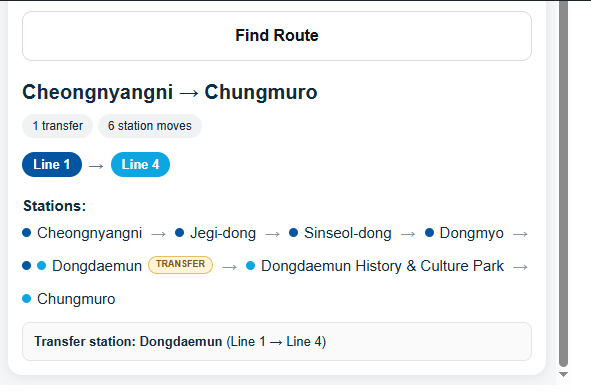
Step 2) Scroll down slightly in the sidebar to view the complete route below.
Looking for a station that isn’t in the list above? Use the finder below. It covers 422 stations on Lines 1–9, the Airport Railroad (AREX) and the Shinbundang Line.
Explore the Seoul Subway Map and Attractions Near Major Stations
Tap a line to show only that line and the attractions near its stations. Tap it again to see all lines.
Schematic map – not to scale. Station positions do not match real distances or geography.
Seoul’s subway system is one of the most convenient ways to explore the city. However, for first-time visitors, the large number of subway lines, stations, and transfer points can make route planning confusing.
That is why Seoul Travel Tips developed its own Seoul Subway Route Finder around 41 carefully selected major subway stations that are particularly useful for travelers visiting Seoul.
Rather than attempting to include every subway station in Seoul, this tool focuses on 41 major stations that connect important tourist areas, transportation hubs, shopping districts, business areas, and popular neighborhoods.
The user simply selects one of these stations as the Departure and another as the Destination, and the program calculates a route according to a simple priority system.
Same-line direct route → minimum transfers → if transfers are equal, minimum station moves
This makes the tool different from a general-purpose subway navigation service. It was specifically developed as a practical Seoul travel tool for international visitors.
A Subway Route Finder Built Around 41 Major Stations
The most important feature of the Seoul Travel Tips Route Finder is its carefully selected 41-station network.
These stations were chosen to represent important areas that travelers are likely to visit during a Seoul trip.
The 41 stations include major transportation hubs and tourist-area stations such as:
- Incheon International Airport Terminal 1
- Gimpo International Airport
- Seoul Station
- Hongik University
- Sinchon
- Digital Media City
- Gongdeok
- Myeongdong
- Jonggak
- Jongno 3-ga
- Gyeongbokgung
- Anguk
- Dongdaemun
- Yongsan
- Wangsimni
- Cheongnyangni
- Itaewon
- Seongsu
- Gangnam
- Jamsil
- Yeouido
These are part of the selected major-station network, together with the other stations included in the 41-station database.
The important point is that the program is not simply a subway map embedded into the website.
The 41 stations were deliberately selected and connected within the Route Finder so that visitors can use them directly as both starting points and destinations.
Why 41 Stations?
A complete Seoul metropolitan subway network contains a very large number of stations.
For official information about Seoul’s subway system, routes, fares, and transportation guidelines, see the [Seoul Metropolitan Government’s Subway Guide].
Including every station would certainly provide more coverage, but it would also make a travel-focused tool much more complicated.
Seoul Travel Tips takes a different approach.
The purpose of this Route Finder is not to replace a professional subway navigation application.
Instead, it is designed to answer a simpler travel question:
“I am at one important Seoul station. Which route should I take to another important station with as few transfers as possible?”
By concentrating on 41 major stations, the tool can remain relatively simple and easy for an international traveler to understand.
For example, a traveler can select:
Hongik University → Myeongdong
or:
Seoul Station → Gyeongbokgung
or:
Gangnam → Jamsil
or:
Cheongnyangni → Chungmuro
The same route-search system is used regardless of which two supported stations are selected.
Every Selected Station Can Be a Departure or Destination
One of the important design principles of the program is that the 41 stations are not merely displayed as reference points.
They are actual selectable stations in the Route Finder.
That means the selected stations can be used in either direction.
For example:
Seoul Station → Hongik University
can also be searched as:
Hongik University → Seoul Station
Likewise:
Gangnam → Myeongdong
can be reversed:
Myeongdong → Gangnam
This creates a simple station-to-station route system within the 41 selected stations.
Instead of searching through an enormous list of every Seoul subway station, travelers can select from the stations that are most relevant to the Seoul Travel Tips travel network.
How to Use the Seoul Subway Route Finder
Using the tool is intentionally simple.
Step 1 – Select your departure station
Choose the station where your subway journey begins.
For example:
Cheongnyangni Station
The interface displays the station’s subway line information and identifies transfer stations where applicable.
Step 2 – Select your destination station
Next, choose the station closest to your destination.
For example:
Chungmuro Station
Chungmuro is served by Line 3 and Line 4, making it an important transfer station.
Step 3 – Click “Find Route”
Press the Find Route button.
The program then searches the route connections within its 41-station subway network.
Step 4 – Check the route
The result is based on the Route Finder’s predefined priority:
1. Same-line direct route
2. Minimum number of transfers
3. If transfer counts are equal, minimum station moves
This gives travelers a consistent and easy-to-understand method for selecting a route.
The Route Priority Is Designed for Simplicity
The Seoul Subway Route Finder does not simply attempt to find the shortest possible route.
Its primary goal is to make the subway journey easier to understand.
Suppose there are two possible routes:
Route A
1 transfer
15 station moves
Route B
2 transfers
10 station moves
The Route Finder prioritizes Route A, because reducing the number of transfers comes first.
Now suppose there are two routes:
Route A
1 transfer
15 station moves
Route B
1 transfer
10 station moves
Both routes have the same number of transfers, so the program then gives priority to Route B, which has fewer station moves.
This creates a clear hierarchy:
Direct route first → fewer transfers → fewer station moves
Why This Approach Is Useful for International Visitors
For someone familiar with Seoul’s subway system, changing trains may be straightforward.
For a first-time visitor, however, a transfer can involve several additional steps:
- Finding the correct transfer signs
- Locating another platform
- Checking the subway line number
- Checking the direction of the train
- Walking through a large station
- Making sure the correct train is boarded
Large transfer stations can be particularly confusing when travelers are carrying luggage or traveling with children.
Therefore, reducing the number of transfers can make the journey easier to follow.
This is the basic idea behind the Seoul Travel Tips Route Finder.
It does not try to make every possible transportation calculation.
Instead, it focuses on one practical question:
Which available route requires fewer transfers?
41 Stations Connected to Seoul Travel Tips’ Travel Network
Another important aspect of this project is that the 41 subway stations are part of a larger Seoul Travel Tips travel network.
The website is being developed around major tourist destinations and practical travel tools rather than simply publishing general information.
The subway stations therefore provide an important connection between the website’s attraction guides and the actual transportation travelers need to use.
For example, a traveler reading about Gyeongbokgung Palace can identify the appropriate subway station and then use the Route Finder to understand how to reach another major area of Seoul.
Similarly, travelers visiting Myeongdong, Hongdae, Gangnam, Itaewon, Seongsu, Jamsil, Yeouido, Dongdaemun, or Jongno can use the subway network as part of their overall trip planning.
More Than a Subway Map
A subway map tells you where the lines and stations are.
The Seoul Subway Route Finder is designed to do something more practical:
Choose two stations → calculate the route → prioritize fewer transfers → follow the route.
This makes it particularly suitable for travelers who don’t want to spend a lot of time studying the entire Seoul subway map.
The tool also fits naturally with other Seoul Travel Tips features.
For example:
Tourist attraction guide
↓
Find the nearest major subway station
↓
Use Seoul Subway Route Finder
↓
Find an easier route between stations
↓
Use a map service for the final walk to the destination
This creates a more complete travel experience.
An Important Limitation
The Route Finder is designed specifically around the 41 selected major stations.
It is therefore not intended to function as a complete replacement for Seoul’s official public transportation systems or real-time navigation services.
The program’s route calculation also does not use actual travel time or physical walking distance as its primary route criteria.
For actual travel, travelers should still check station signs, train direction, service information, operating conditions, and other real-world circumstances.
The purpose of this tool is simpler:
To make route selection between Seoul’s major travel stations easier.
Designed Specifically for Seoul Travelers
The Seoul Subway Route Finder represents one of the key ideas behind Seoul Travel Tips: useful travel information should be practical, not just informational.
The website doesn’t simply tell travelers that Seoul has a large subway network.
The Route Finder turns a selected part of that network into a tool that visitors can actually use.
With 41 carefully selected major stations, travelers can choose a departure station and destination station and receive a route based on a clearly defined system.
The result is a focused travel tool that connects important areas of Seoul without overwhelming visitors with the entire subway network.
Start Exploring Seoul by Subway
Seoul can seem complicated when you first look at its subway map.
But you don’t need to understand the entire network to begin exploring the city.
Start with the station closest to where you are, choose your destination from the supported major stations, and use the Route Finder to identify a route with fewer transfers.
The basic principle is easy to remember:
Direct route first → fewer transfers → fewer station moves
The Seoul Subway Route Finder was developed around 41 major Seoul subway stations specifically to provide travelers with a simpler way to plan journeys between important areas of the city.
Whether you are traveling between the airport and Seoul, moving from Hongdae to Myeongdong, visiting Gyeongbokgung from another part of the city, heading from Gangnam to Jamsil, or exploring Seoul’s major tourist districts, the Route Finder provides a straightforward starting point for planning your subway journey.
Choose your station. Choose your destination. Find your route. Explore Seoul.